Loading Events

20 de Febrero Caminata en Rabun Bald / February 20th Rabun Bald Bilingual Hike

February 20, 2024 Bilingual Hike to Rabun Bald

February 20, 2024 Bilingual Hike to Rabun Bald

Ubicación y más detalles:

Dirigido por el director de Blue Ridge Bartram Trail Conservancy, Brent Martin, y tambien por AmeriCorp Vista, Gillian Watson. Este evento contará con interpretaciones traducidas en español de la flora local, fauna y paisaje locales que William Bartram escribio durante su tiempo en el oeste de Norte Carolina.

Este evento es un oportunidad para compartir las maravillas del Bartram Trail con más personas en el condado de Macon y sus alrededores. Nuestro objetivo es hacer que el Bartram Trail sea accesible y agradable para todos.

¡Esperamos verlos a todos ahi!

Por favor confirme su presencia a continuación para ayudarnos a planificar el evento.

Entre “Beegum Gap” en Google Maps o sigue estas direcciones:

Direcciones desde Franklin:
Dirigirse al sur por US-23 S/US 441 S en dirección a Clayton/Atlanta
Gira a la izquierda con dirección a Hwy 246 (aproximadamente una milla después de entrar en Georgia)
Después de 4.2 millas, gira a la derecha con dirección a Old Mud Creek Rd
Después de 2.9 millas, gira pronunciadamente a la derecha con dirección a Kelsey Mountain Rd
Después de 0.3 millas, continua recto hacia Rabun Bald Trail
En 150 pies está el comienzo del sendero llamado “Beegum Gap” a la izquierda

—————————————-

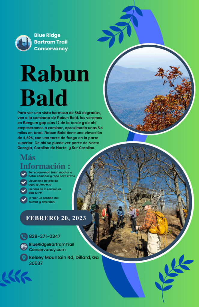
To experience an amazing 360-degree view, join us for the Rabun Bald hike. Guided by Brent Martin, the Director of the Blue Ridge Bartram Trail Conservancy, and Gillian Watson, an AmeriCorps Vista member. We will meet up at Beegum Gap at noon to commence the hike, which spans approximately 3.4 miles in total. Rabun Gap has an elevation of 4,696, with a fire tower located at the top. From there, you can see parts of North Georgia, North Carolina, and South Carolina. The trail is more elevated and a bit challenging, but it will be an adventure, and the view from the top will be worth it!

Join us in this event that will open opportunities for everyone in Macon County and the surrounding area to be able to experience the wonders that the Bartram Trail holds. Our goal is to enhance trail accessibility and enjoyment for everyone, and this hike marks a small yet significant step toward achieving that.

Common FAQs

Nope!

Less experienced hikers might benefit from hiking more popular sections, where access is easier and where they might feel more comfortable knowing that there are other hikers close by to answer questions about logistics, trail conditions, and so on. Most of the major access points for the trail in North Carolina have informational kiosks.
Popular Sections/Trailheads include: Warwoman Dell, Wallace Branch, Little Tennessee River Greenway, Wayah Bald, & Appletree Campground

Whether planning a day hike on the Bartram Trail or an extended trip, consider your abilities for elevation gain and the associated distances, as these are two major factors in enjoying your hike. Many of the Bartram sections are also easier to travel north to south, as there is a general loss of elevation as one proceeds south, particularly in Georgia. Regardless, if you are not an experienced hiker, start with hikes under five miles, and check our website for information on trail conditions.


Short Answer: the best time to hike is anytime you can get away on the trail & anytime there is a weather forecast that doesn’t have dangerous conditions as a possibility.

Long Answer: Spring and Fall are the two seasons most pleasant for hiking, as well as the two seasons when wildflowers are the most spectacular. Depending on the section you’re hiking, hikers must prepare for stream crossings, steep elevation gains and losses, uneven and rocky terrain, lack of water, rapidly changing weather conditions, or all of the above. Temperatures are cooler at the higher elevations, and summer rains can leave a hiker chilled to the point of hypothermia if caught unprepared. Winter can include crisp, bright, warm days followed by subfreezing temperatures, snow, and/or ice. The Bartram Trail passes through a high rainfall area, with over 100 inches of rain in a year not uncommon. Choose a time and difficulty that will best suit what you are looking to gain/experience with your BT hike!

Practice the seven principles of Leave No Trace:

  1. Plan Ahead & Prepare: Includes reaching your destination, checking regulations, preparing for potential hazards, & packing appropriately.
  2. Travel & Camp on Durable Surfaces: Choose established trails and campsites, or areas that are already impacted, to avoid disturbing vegetation and fragile ecosystems.
  3. Dispose of Waste Properly: Pack out everything you pack in, including food scraps, toilet paper, and other trash. Human waste should be disposed of properly, away from water sources and campsites.
  4. Leave What You Find: Do not remove natural objects like rocks, plants, or artifacts. Leave the environment as you found it for others to enjoy.
  5. Minimize Campfire Impacts: Use existing fire rings or fire pans, keep fires small, and ensure fires are completely extinguished before leaving.
  6. Respect Wildlife: Observe wildlife from a distance, avoid disturbing their habitat, and do not feed animals.
  7. Be Considerate of Other Visitors: Respect other people's outdoor experiences by being mindful of noise levels, keeping a safe distance, and being courteous on trails.

Learn More

HERE is a blog post that goes more in depth on having a safe trail experience. In short:

  • Always follow the yellow blazes!
  • Make sure you bring plenty of water and food for your journey.
  • Have someone at home know where you are and how long you plan on being there.
  • Purify your drinking water.
  • Be aware of hunting season (typically from early autumn through February).
  • Be prepared for wading stream sections and how rain can cause streams to swell quickly.
  • Check Forest Service Websites for road closures.
  • Bring enough supplies to last through an emergency.
  • Prepare for the worst, hope for the best!

Yes, but it is advised to keep your pets leashed and under control. Bear, deer, coyotes, and many other animals share the forest that the Bartram trail passes through. A dog you think might be under your control but unleashed could take off after anything, and you might spend a long time trying to find it – and it could have had a bad encounter resulting in injuries or death. Also, it is respectable to other hikers who may not appreciate dogs, as well as other dog owners who keep their dogs leashed.

What you bring on a hike can differ greatly based on distance, topography, weather, and what your interests are for the experience. Check the weather! Some basic items for a short hike (2-4 miles) are a daypack with water, snacks, rain gear (even if there’s a slight chance), and a basic first aid kit. For a longer hike, be prepared for a change in weather (raingear, extra layer, extra socks).

Still have questions?

We're here to help!

Stay in Touch

Subscribe to stay up-to-speed on trail news, upcoming events, merch drops, trail conditions, and more.